
Hurricane Ian makes landfall in Florida as Category 4 storm
Hurricane Ian made landfall on the southwest coast of Florida as a monster Category 4 storm on Wednesday with powerful winds and torrential rains threatening to cause "catastrophic" damage and flooding.
The National Hurricane Center said the eye of the "extremely dangerous" hurricane slammed into the barrier island of Cayo Costa, west of the city of Fort Myers, at 3:05 pm (1905 GMT).
Dramatic television footage showed churning water submerging roads and sweeping away cars as the hurricane pounded the coastal city of Naples to the south of Fort Myers.
The NHC said Ian was packing maximum sustained winds of 150 miles per hour (240 kilometers per hour) when it made landfall and was already "causing catastrophic storm surge, winds and flooding in the Florida peninsula."
Ian is expected affect several million people across Florida and in the southeastern states of Georgia and South Carolina and may have already claimed its first casualties.
The US Border Patrol said 20 migrants were missing after their boat sank. Four Cubans who survived swam to shore in the Florida Keys and three were rescued at sea by the coast guard.
As hurricane conditions spread, forecasters warned of a looming once-in-a-generation calamity.
"This is going to be a storm we talk about for many years to come," said National Weather Service director Ken Graham. "It's a historic event."
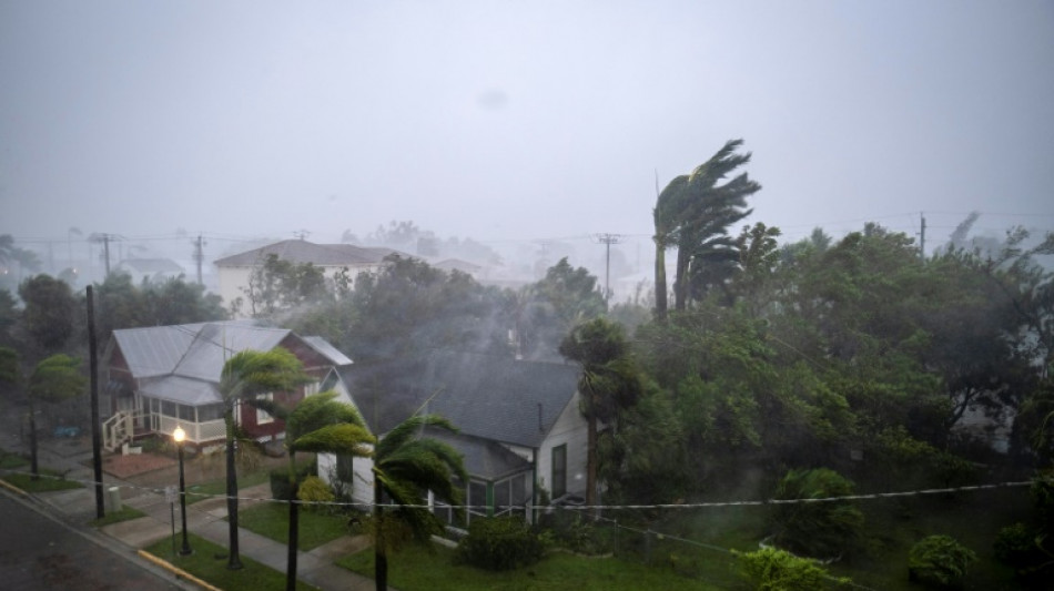
Punta Gorda, north of Fort Myers, was being pounded by torrential rain and streets emptied as the howling winds ripped fronds off of palm trees and shook electricity poles.
Some 2.5 million people were under mandatory evacuation orders in a dozen coastal Florida counties, with several dozen shelters set up, and voluntary evacuation recommended in others.
For those who decided to ride out the storm, authorities stressed it was too late to flee and that residents should hunker down and stay indoors.
- 'Major impacts' -
With winds of 150 mph as it made landfall, Ian is just seven mph shy of Category 5 intensity -- the strongest on the Saffir-Simpson scale.
Airports in Tampa and Orlando stopped all commercial flights, and 850,000 households were already without power.
But that was a "drop in the bucket" compared with the outages expected over the next 48 hours, Florida Governor Ron DeSantis said.
"This is going to be a nasty, nasty day, two days," he added.
With up to two feet (61 centimeters) of rain expected to fall on parts of the so-called Sunshine State, and a storm surge that could reach devastating levels of 12 to 18 feet (3.6 to 5.5 meters) above ground, authorities were warning of dire emergency conditions.
"This is a life-threatening situation," the NHC warned.
The storm was set to move across central Florida before emerging in the Atlantic Ocean by late Thursday.
- 'Nothing is left here' -
Ian a day earlier had plunged all of Cuba into darkness after battering the country's west as a Category 3 storm and downing the island's power network.
"Desolation and destruction. These are terrifying hours. Nothing is left here," a 70-year-old resident of the western city of Pinar del Rio was quoted as saying in a social media post by his journalist son, Lazaro Manuel Alonso.
At least two people died in Pinar del Rio province, Cuban state media reported.
In the United States, the Pentagon said 3,200 national guardsmen were called up in Florida, with another 1,800 on the way.
DeSantis said state and federal responders were assigning thousands of personnel to address the storm response.
"There will be thousands of Floridians who will need help rebuilding," he said.
As climate change warms the ocean's surface, the number of powerful tropical storms, or cyclones, with stronger winds and more precipitation is likely to increase.
The total number of cyclones, however, may not.
"There remains a consensus that there will be fewer storms, but that the strongest will get stronger," Lackmann told AFP.
R.Marconi--IM


